
Rather than distributing actual large-format posters via mail, we now offer several poster-sized and wall-sized high-quality maps in the Adobe PDF format distributed on CD/DVDs. All PDFs are designed to be printed on high-quality large-format plotters and cannot be edited. The user may print these out on their own large-format plotter, take the media to a 3rd-party vendor such as Kinko's, or print hard poster boards for professional quality. These maps are all original creations by Paul Wessel using GMT scripts.
The resulting PostScript plots were converted to PDF and are limited to printing only (no editing/copying). To achieve the highest image resolution, the 30x30 arc second SRTM30+ grid was specially processed with GMT and proprietary Geoware tools and resampled at the final pixel resolution (300 dpi) in the map projection used for each map. Tectonic maps have high-quality relocated epicenters based on the International Seismological Center and Holocene volcanoes from the Smithsonian Institution data set.
Buyers of a map must accept the following license terms:
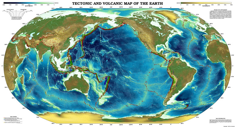
| Wall-sized Tectonic Map (Mercator Projection) Size: 186 x 88 inches (4.75 x 2.25 m) [2.3 Gb] | |
|---|---|
 |
NEW: HUGE wall map of the Earth shows the topography and bathymetry relief with superimposed seismicity and volcanism.
Repeats Africa to give 450 degrees of longitude extent. Limited to 72 degrees S/N. Each pixel approximately represents
30x30 arc seconds or area. The display comes as a mosaic of 5 separate vertical
PDF strips (each 88 x 39 inches or 223.5 x 99 cm) that must be assembled after printing and professionally mounted on a wall. Great for Ocean and Earth science
institutes, conference rooms and lobbies. Make sure to measure your wall-space before ordering! Unit Price: $ 900.00. Shipping and Handling is $ 5.00. |
| Wall-sized Tectonic Map (Polar Stereographic Projection) Size: 134 x 88 inches (3.40 x 2.25 m) [1.8 Gb] | |
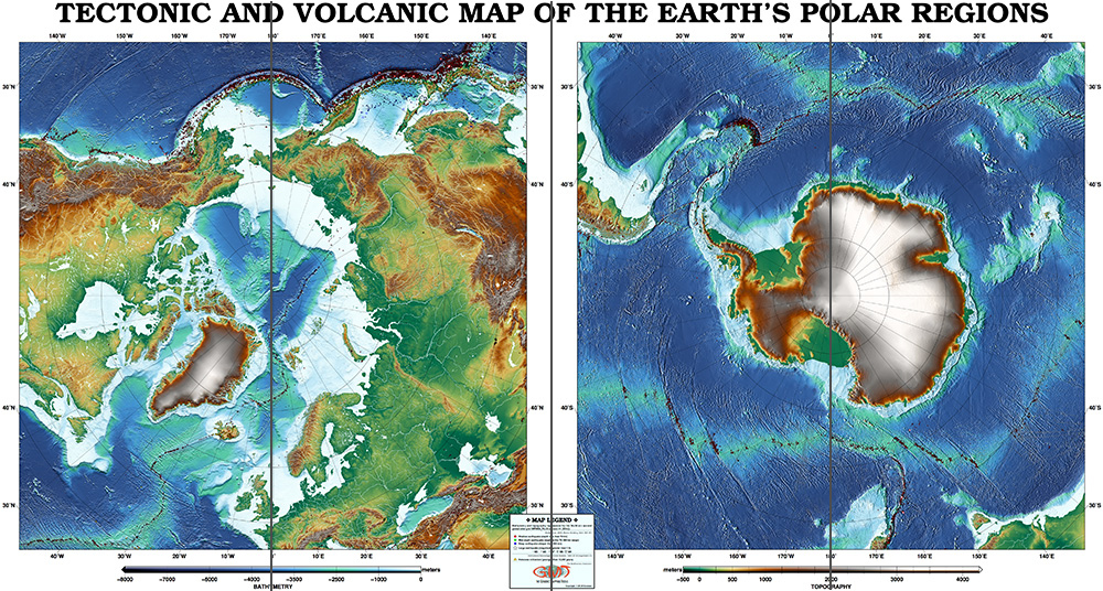 |
NEW: HUGE wall map of the Earth shows the topography and bathymetry relief with superimposed seismicity and volcanism.
Both polar regions are shown in separate panels. Each pixel approximately represents
30x30 arc seconds or area. The display comes as a mosaic of 4 separate vertical
PDF strips (each 88 x 33.5 inches or 223.5 x 85 cm) that must be assembled after printing and professionally mounted on a wall. Great for Ocean and Earth science
institutes, conference rooms and lobbies. Make sure to measure your wall-space before ordering! Unit Price: $ 750.00. Shipping and Handling is $ 5.00. |
| Large Tectonic Map (Mercator Projection) Size: 84 x 42 inches (214 x 107 cm) [640 Mb] | |
 |
NEW: Large wall map PDF of the Earth shows the topography and bathymetry relief with superimposed seismicity and volcanism.
Repeats Africa to give 450 degrees of longitude extent. Limited to 72 degrees S/N, displayed in a single panel. Unit Price: $ 125.00. Shipping and Handling is $ 5.00. |
| Large Tectonic Map (Polar Stereographic Projection) Size: 66 x 36 inches (168 x 92 cm) [500 Mb] | |
 |
NEW: Large wall map PDF of the Earth shows the topography and bathymetry relief with superimposed seismicity and volcanism.
Both polar regions are shown separately, displayed in a single panel. Unit Price: $ 100.00. Shipping and Handling is $ 5.00. |
| Global Tectonic Map (Robinson Projection) Size: 65 x 36 inches (165 x 92 cm) [702 Mb] | |
 |
Global PDF map of the Earth shows the topography and bathymetry relief with superimposed seismicity and volcanism. Unit Price: $ 100.00. Shipping and Handling is $ 5.00. |
| Alpine-Himalayan Tectonic Map (Oblique Mercator Projection) Size: 110 x 33 inches (280 x 85 cm) [930 Mb] | |
 |
PDF Map of the Alpine-Himalayan system shows the topography and bathymetry relief with superimposed seismicity and volcanism.
Displayed as an oblique Mercator projection with the oblique equator following the complicated plate boundary. Unit Price: $ 75.00. Shipping and Handling is $ 5.00. |
| Americas Tectonic Map (Oblique Mercator Projection) Size: 80 x 33 inches (200 x 85 cm) [770 Mb] | |
 |
PDF Map of North and South America shows the topography and bathymetry relief with superimposed seismicity and volcanism.
Displayed as an oblique Mercator projection with the oblique equator following the central meridian. Unit Price: $ 75.00. Shipping and Handling is $ 5.00. |
| Pacific Ring of Fire Tectonic Map (Azimuthal Equidistant Projection) Size: 51 x 36 inches (130 x 90 cm) [275 Mb] | |
 |
PDF Map of the Pacific Ocean Basin and surrounding "ring of fire" shows the topography and bathymetry relief with superimposed seismicity and volcanism.
Displayed as an azimuthal equidistant projection with center at (175W, 0). Unit Price: $ 75.00. Shipping and Handling is $ 5.00. |
| North America - Atlantic - Europe Relief Map (Azimuthal Equal-Area Projection) Size: 50 x 36 inches (125 x 90 cm) [434 Mb] | |
 |
PDF Map of the northern hemisphere covering North America to western Europe region shows the region's topography and bathymetry relief.
Displayed in an Azimuthal Equal-Area projection. Unit Price: $ 50.00. Shipping and Handling is $ 5.00. |
| Central North Atlantic Relief Map (Oblique Mercator Projection) Size: 45 x 36 inches (115 x 90 cm) [382 Mb] | |
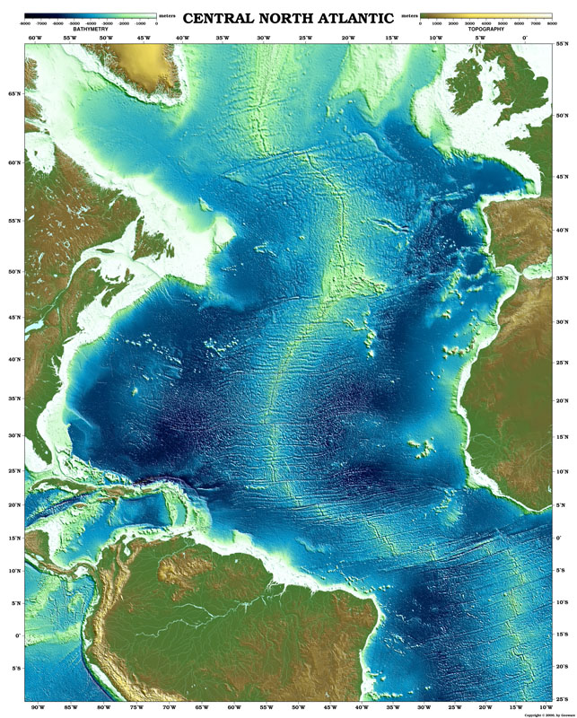 |
PDF Map of the Central North Atlantic Ocean Basin and surrounding continents shows the topography and bathymetry relief.
Displayed as an oblique Mercator projection so average spreading is horizontal. Unit Price: $ 50.00. Shipping and Handling is $ 5.00. |
| East Asian Relief Map (Azimuthal Equal-Area Projection) Size: 50 x 36 inches (125 x 90 cm) [256 Mb] | |
 |
PDF Map of the East Asian region shows the topography and bathymetry relief.
Displayed in an Azimuthal Equal-Area projection. Unit Price: $ 50.00. Shipping and Handling is $ 5.00. |
| Mediterranean to SouthWest Asia Relief Map (Azimuthal Equal-Area Projection) Size: 48 x 36 inches (120 x 90 cm) [225 Mb] | |
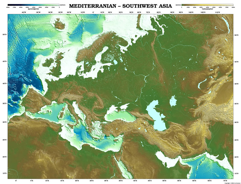 |
PDF Map of the Mediterranean area stretching into SouthWest Asia shows the region's topography and bathymetry relief.
Displayed in an Azimuthal Equal-Area projection centered on (50N, 35E). Unit Price: $ 50.00. Shipping and Handling is $ 5.00. |
Shipping/Handling charges include Worldwide Airmail shipping of the CD/DVDs. We recommend you order and pay using your credit card with the above free PayPal service, available from most countries. Alternatively, we accept (1) Company Purchase Orders or (2) Pre-payment by check in US dollars drawn on a US bank (no Eurochecks, sorry). Foreign companies who insist on bank wire must pay an extra USD 5.00 in wiring fee. Print out and fill in the order form and send it with your purchase order or check to
Geoware, c/o Paul Wessel
91-1350 Kaikohola Street
Ewa Beach, HI 96706-6260
USA
Also notify us by e-mail of your intent to purchase products by purchase orders or check so that we may prepare your order prior to the arrival of your mail. Please contact us should you require more information.
This page was last modified on Wednesday, Feb. 1, 2017.